TROPICAL STORM WARNING FOR TUESDAY AUG 4


drummerboy said:
is there a TL;DR version of Max's last post?
Tropical storm is coming. Lots of rain. Probably some flooding. Lots of wind. Maybe some tornadoes.
Edit: weak tornadoes

drummerboy said:
is there a TL;DR version of Max's last post?
Oh, FFS, this is what happens when I post before coffee. I posted the attachments and forgot the actual post!
What it should have said:
Tropical Storm Isaias, Monday Aug 3 Update
The MAPSO area is under a TROPICAL STORM WARNING and a FLASH FLOOD WATCH tomorrow, Tuesday Aug 4
There is good model consensus on a track that brings Isaias through our area Tuesday.
Key points:
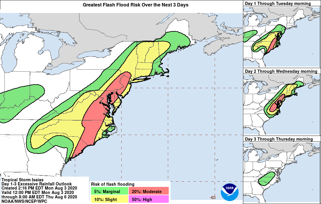
Rain: NWS forecasts 2 - 4 inches with more in isolated rain bands. There is also a potential PRE rain event tonight although this looks limited to about 1/2 inch if it occurs. Total 24 hour rain forecast 2 - 6 inches.
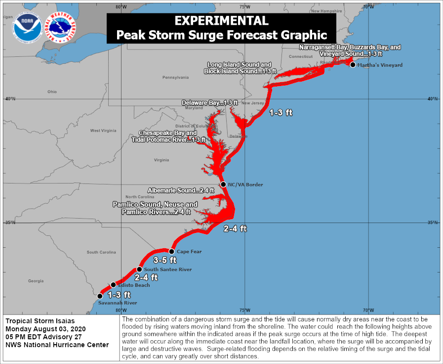
Wind: The highest winds are more likely to be east of us over Long Island, but the potential does exist here for an extended period of 20 - 40 mph winds with some 50+ gusts on Tuesday afternoon and early evening. The good news is that Isaias is expected to pass relatively quickly, meaning that the worst winds could be limited in duration to 2 - 3 hours.
Flooding: Local flash flooding, road ponding and local field and stream only. The river should be able to handle this event.
Timing: Chance of heavy rain from the PRE event overnight Monday. Rain likely by mid morning Tuesday becomes heavy Tuesday afternoon and early evening, tapering off by midnight. Winds Tuesday afternoon and early evening.


max_weisenfeld said:
drummerboy said:
is there a TL;DR version of Max's last post?
Wind: The highest winds are more likely to be east of us over Long Island, but the potential does exist here for an extended period of 20 - 40 mph winds with some 50+ gusts on Tuesday afternoon and early evening. The good news is that Isaias is expected to pass relatively quickly, meaning that the worst winds could be limited in duration to 2 - 3 hours.
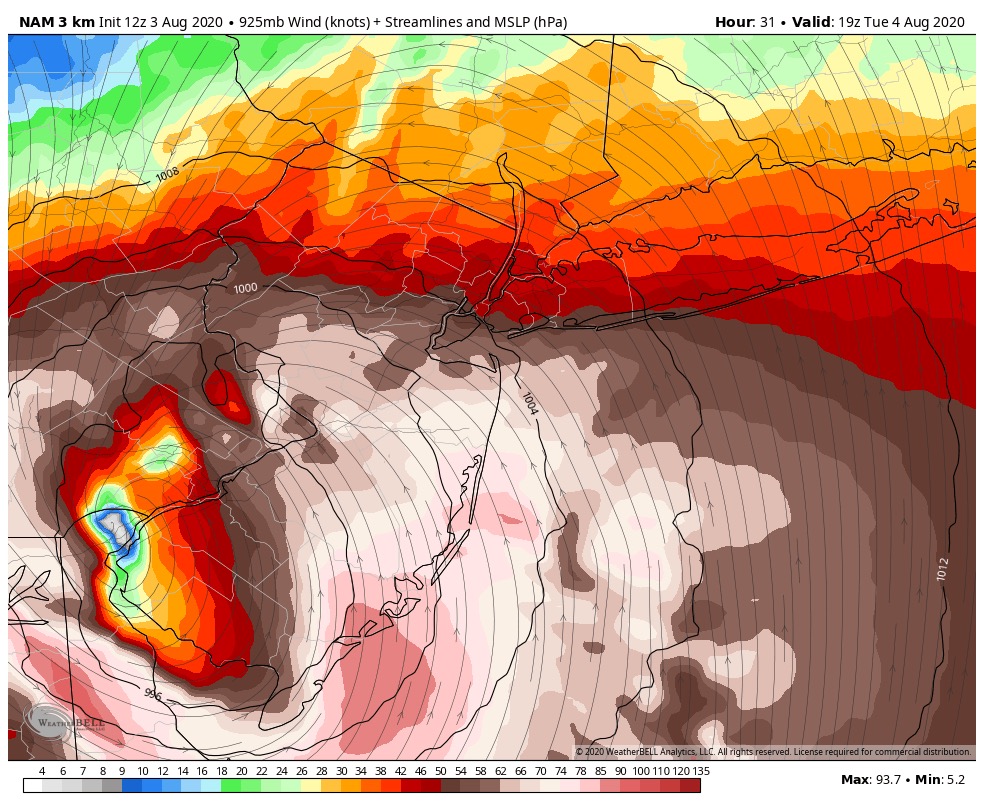
FWIW as semantic as it may be I'm not sure I totally agree with this. Forecast track has moved slightly west and at least a couple of models bring the strongest wind right over us. If this thing is still largely tropical as it approaches, the max wind will be closer to the center. If it becomes more baroclinic, the wind field will expand and stronger wind may make its way further east. Either way, we will see quite a bit of wind tomorrow.
max_weisenfeld said:
Fair. I was working off the 00z runs when I wrote that
Typically I think you'd be on track with the assumption -- LI will almost always see stronger wind than here. You can sort of see in that NAM3 plot the extratropical transition too. The western track also really opens the door to some tornadoes here.
baroclinic?
I read the definition, and I still don't understand it.
drummerboy said:
baroclinic?
I read the definition, and I still don't understand it.
A cyclone can be defined in two ways: barotropic and baroclinic. A tropical cyclone (hurricane, tropical storm) is barotropic, in that the circulation is stacked perfectly in the vertical, where the upper-level (think height of the jet stream) circulation is aligned directly above the low-level (near-/surface) circulation. As this is the case, any substantial amount of vertical shear (change in wind speed and/or direction with height) will act to disrupt that alignment of the tropical cyclone and weaken it as the upper- and lower-level circulations become detached from one another. Barotropic systems are also non-frontal, in that they lack any sort of cold or warm fronts at the surface.
A baroclinic system (nor'easter, "bomb", etc.) on the other hand is tilted in the vertical, with a strengthening (weakening) system characterized by the upper-level low being found to the west (east) of the lower-level circulation. In this case, vertical shear actually acts to help intensify the circulation. Baroclinic systems are also characterized by fronts -- in fact, baroclinic by definition means there must be a horizontal temperature gradient present.
As many tropical systems make their way up the east coast, they are impacted by the influence of upper-level troughs traversing the jet stream over the North American continent. The shear associated with the upper-level troughs acts to tilt the cyclone in the vertical and transition it from barotropic (tropical) to baroclinic (extra-tropical). As this occurs, the distribution of the near-/surface wind field changes from a configuration where the maximum wind is found along the edges of the minimum in surface pressure (the eye wall) to one where the maximum wind is found further out from the center. In the tropical case, the wind speed is typically much higher but far more concentrated than in the mid-latitude/extratropical case. This is exactly what happened with Sandy as it approached and became extratropical. Sandy was not a tropical system (i.e., a Hurricane) when it made landfall in 2012.
With respect to Isaias, this extra-tropical transition from barotropic (tropical) to baroclinic (extratropical) is likely going to happen either over or just before it gets to us. As you can see in the wind map in my previous post, the wind field is rather large with maximum wind speeds found to the east of the low pressure center. It is also asymmetric, another signature of extra-tropical transition. The only thing that gives me pause in saying it is extra-tropical by the time it reaches us is the lack of a noticeable warm front in that image. I imagine a front would emerge relatively soon after that image is valid.


Last year, our president suggested a hydrogen bomb be dropped in the middle of one of the impending hurricanes. Shouldn't this be done now to Hurricane EE-SAH-YEE-YAS?
Why should we have to put up with floods, rain, tornadoes and thunder and wind?
Ew.
The weather threads are one of the few unsullied by the Great Orange Presence. Let's keep it that way!
mrincredible said:
Ew.
The weather threads are one of the few unsullied by the Great Orange Presence. Let's keep it that way!
Sharpie-gate begs to differ 
mrincredible said:
Ew.
The weather threads are one of the few unsullied by the Great Orange Presence. Let's keep it that way!
Good point. I'll remove him.
got this from PSE&G. Says this might be the strongest storm in years
As PSE&G continues to monitor Isaias, our latest projections show that this storm has been escalating in strength and has the potential to cause a significant number of power outages. We now anticipate that this storm may be one of the strongest to reach New Jersey in years and some outages could last for an extended period.
The energy grid is much stronger than it was just a few years ago, but we are prepared to respond to any outages safely and as quickly as possible with our own crews and additional utility crews that we are bringing in from out of state.
Monday Evening Aug 3 Update
Forecast for tomorrow is more or less on track in that there will be tropical storm conditions, most likely in the afternoon and early evening, as tropical storm Isaias passes more or less directly through our area.
Key take-aways at this time:
1) Timing:
Tonight, Monday, rain likely with a chance of thunderstorms after midnight. Rain is about two hours away, with thunderstorms in the lead over south Jersey.
Tuesday, rain likely all day. Heavy rain and wind as the storm itself approaches. Some disagreement in the models still on the exact track and timing, with the range of projections having the storm here between noon and five and running as late as nine or ten o'clock. Best guess would be early afternoon into early evening.
2) Rain:
The system will be moving fairly quickly, but there is a lot of water in it and 2 - 4" is likely with up to 2" more in areas hit with thunderstorms or particularly intense rain bands. This projection includes any rain from tonight's Predecessor Rain Event, should one occur (looking likely based on the weather in Trenton right now).
2a) Flooding:
Expect small stream flash flooding as well as road ponding and flooded fields and parks at all the usual places.
3) Wind:
This one is trickier. In the last couple of runs the track has shifted westward in some models, and that, along with other effects as the storm passes from the tropics through to post-tropical, could bring us into the heart of the wind field. The NWS has a widespread steady 40mph wind with gusts in the low 50s. If this newer westerly track actualizes, though, winds and gusts could be 10mph higher. This scenarios also raises the (slight but non-zero) possibility of some small tornadoes. Strongly recommend having a reliable weather app loaded and notifications and especially alerts turned on tomorrow, just in case.
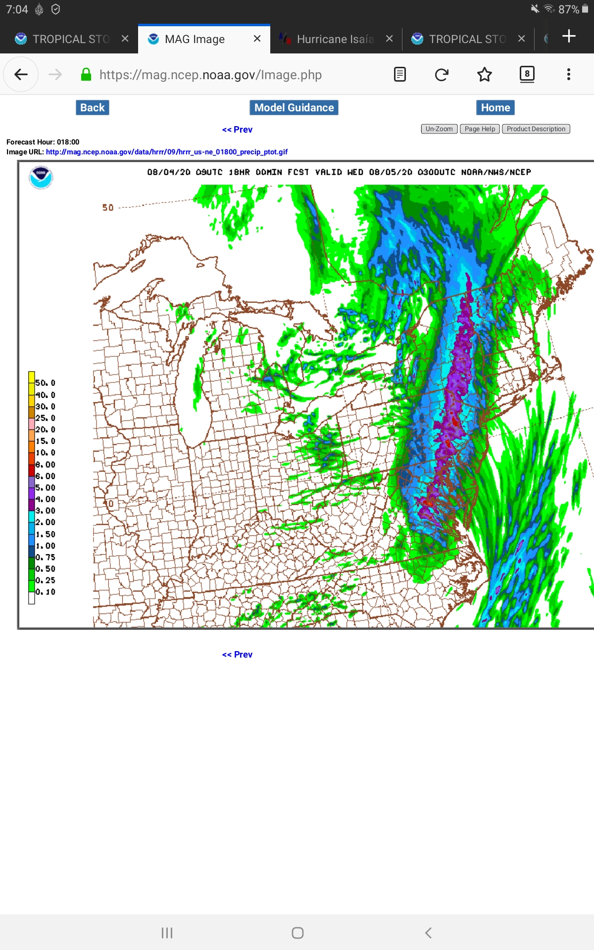
Here is the radar showing the thunderstorms in the Trenton area moving up towards the NYC metro region.
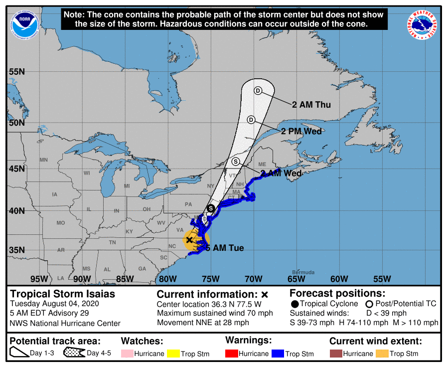
Next is the NAM model showing the newer westerly track and the high winds associated with it. This is 5:00 pm tomorrow
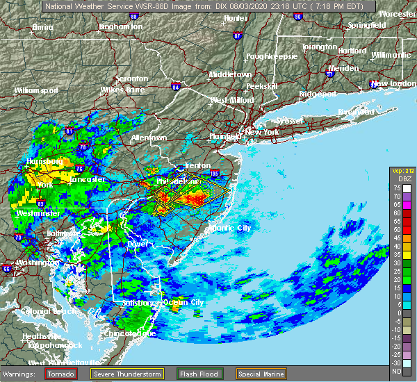
Before WxNut calls me out, those thunderstorms near Trenton are not really a PRE. The models are not handling the PRE well, or it is not happening, but rain is rain, right?
max_weisenfeld said:
Before WxNut calls me out, those thunderstorms near Trenton are not really a PRE. The models are not handling the PRE well, or it is not happening, but rain is rain, right?
Wasn’t gonna call you out! Just some fun thunderstorms. The real show starts tomorrow morning though.
Good morning, Tues Aug 4
Tropical Storm Warning in effect
Flash Flood Watch in effect
Showers and thunderstorms will continue to over spread the area this morning as the storm moves in.
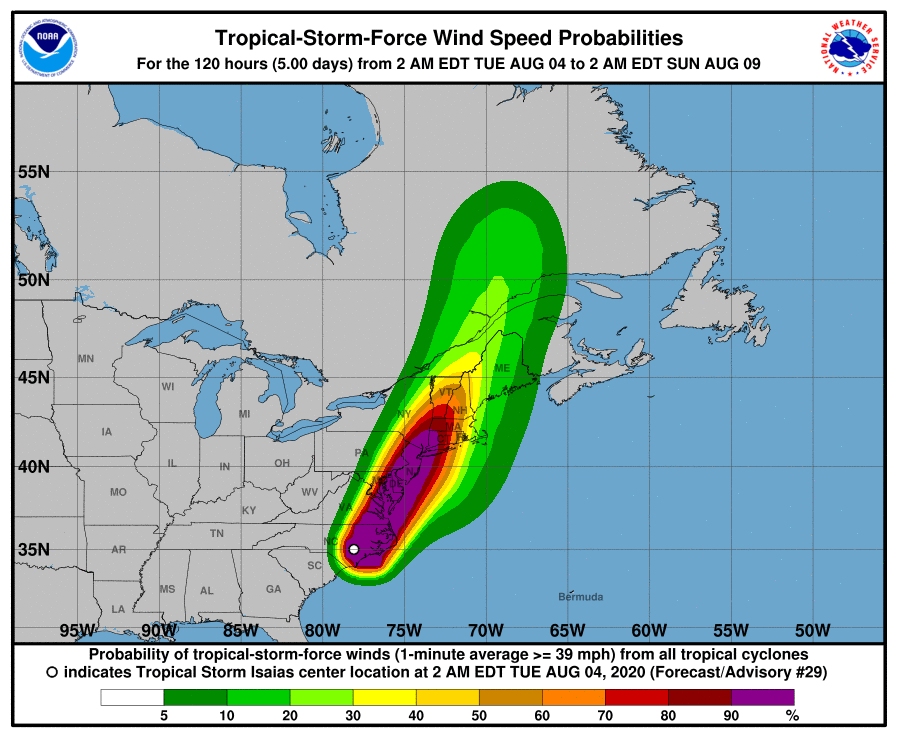
Models are in very good agreement now on track and time. The more westerly track the models were showing yesterday is being strongly signalled this morning. This track brings the heart of the storm west of the MAPSO area up along the NJ-Penn border. This moves the axis of heaviest rain west of us as well, but puts us in the heart of the wind field, changing the focus of the forecast a bit from rain to wind.
TIMING:
A bit faster than yesterday, the wind will start to really pick up just before noon, and start to taper off in the late afternoon, dropping to a strong breeze by seven or eight o'clock. Rain showers and thunderstorm from now until tonight, with the heaviest rain in the thunderstorm in the afternoon.
WIND:
During that window expect steady winds of around 40 mph for two to four hours in the midafternoon, with gusts up to 50-55 mph. There is a bery slight possibility of weak tornadoes.
RAIN:
Expect the lower end of the 2 - 4 inch forecast unless the track shifts back to the east. Higher possible in isolated areas due to thunderstorms.
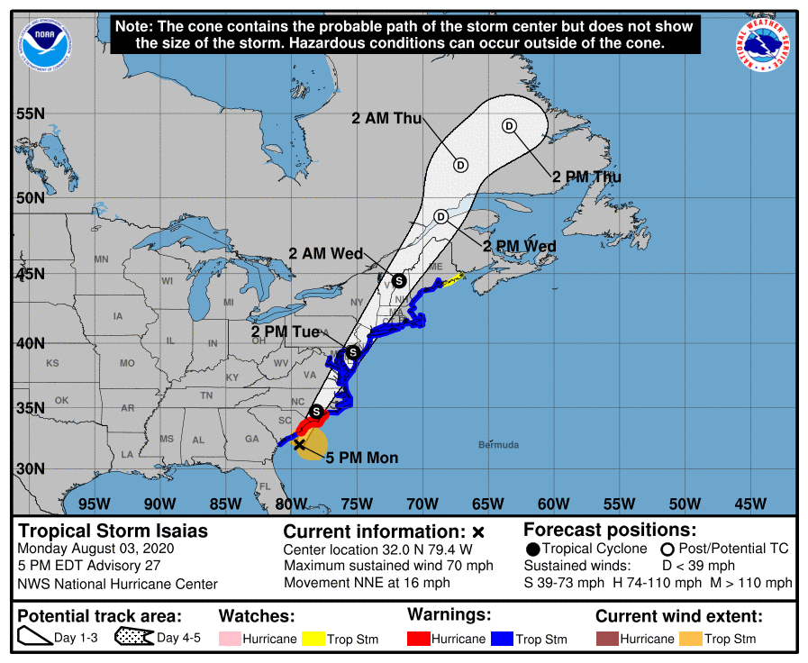
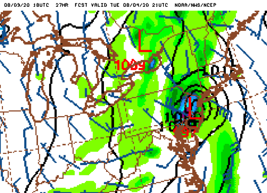
Pictures below are the current track forecast, probability of trop-force winds, and one of the models showing the main rain band to our west.
TORNADO WATCH just added for all of north and central NJ until 4 pm.
Tornado Watch
TORNADO WATCH OUTLINE UPDATE FOR WT 416
NWS STORM PREDICTION CENTER NORMAN OK
720 AM EDT TUE AUG 4 2020

TORNADO WATCH 416 IS IN EFFECT UNTIL 400 PM EDT FOR THE
 FOLLOWING LOCATIONS

NJC001-003-005-007-013-015-017-019-021-023-025-027-029-031-035-
037-039-041-042000-
/O.NEW.KWNS.TO.A.0416.200804T1120Z-200804T2000Z/

NJ
.    NEW JERSEY COUNTIES INCLUDED ARE

ATLANTIC             BERGEN              BURLINGTON
CAMDEN               ESSEX               GLOUCESTER
HUDSON               HUNTERDON           MERCER
MIDDLESEX            MONMOUTH            MORRIS
OCEAN                PASSAIC             SOMERSET
SUSSEX               UNION               WARREN
$


I haven't checked on the message board in a while (sorry Jamie) but came back just for this. Thank you Max and WxNut. The above post about wind versus rain and timing was so helpful as is all you guys contribute. 

Yes, just got the Tornado Watch notification from NYC officials (I run office buildings).
I expect the Frogs, Lice, and Vermin warnings to follow in short order.
max_weisenfeld said:
TORNADO WATCH just added for all of north and central NJ until 4 pm.
Tornado Watch
TORNADO WATCH OUTLINE UPDATE FOR WT 416
NWS STORM PREDICTION CENTER NORMAN OK
720 AM EDT TUE AUG 4 2020

TORNADO WATCH 416 IS IN EFFECT UNTIL 400 PM EDT FOR THE
 FOLLOWING LOCATIONS

NJC001-003-005-007-013-015-017-019-021-023-025-027-029-031-035-
037-039-041-042000-
/O.NEW.KWNS.TO.A.0416.200804T1120Z-200804T2000Z/

NJ
.    NEW JERSEY COUNTIES INCLUDED ARE

ATLANTIC             BERGEN              BURLINGTON
CAMDEN               ESSEX               GLOUCESTER
HUDSON               HUNTERDON           MERCER
MIDDLESEX            MONMOUTH            MORRIS
OCEAN                PASSAIC             SOMERSET
SUSSEX               UNION               WARREN
$
Something to note with this tornado watch: the probability of 2 or more tornadoes within the outlined area is 70%. This is extraordinarily high for this area.
The main threat for tornadoes will be associated with the outlined band of thunderstorms. Several tornado warnings have already been issued for this band and multiple waterspouts have been evident on radar off the coast. Wind shear and low-level instability is extraordinarily favorable for tornadoes in this area today. The blue circle in northern NJ is Maplewood.
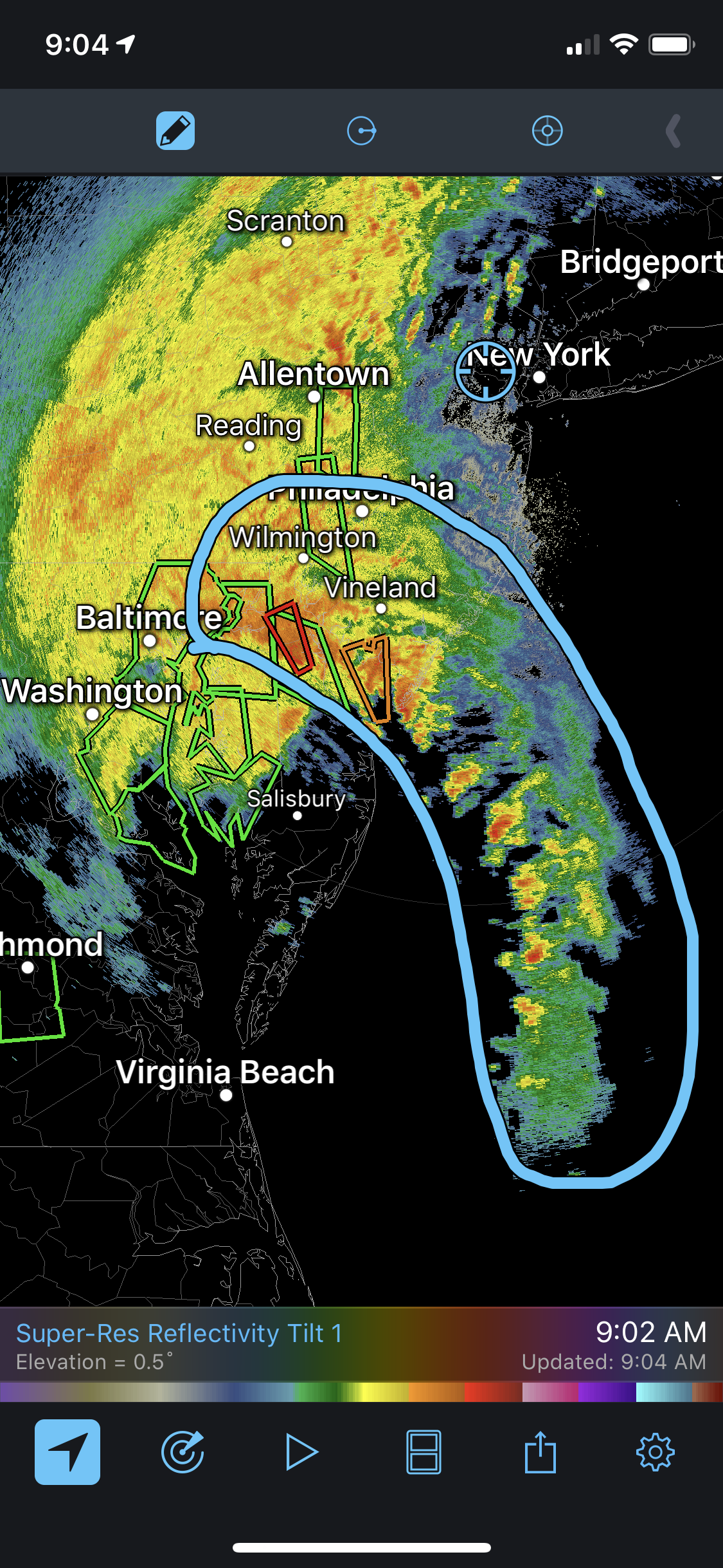
Significant/damaging tornado currently ongoing near Newark, DE. This tornado has had a radar debris signature for a long time. Please take warnings seriously today, the environment in this area is volatile.

Sponsored Business


Promote your business here - Businesses get highlighted throughout the site and you can add a deal.


EE-SAH-YEE-YAS